Tanner Creek Bike
and Hike Adventure
Saturday, 27 July 2002
Scott and Ellen set out to do reconnaissance
on a possible campsite on Tanner Creek.
Years ago Scott and the kids had been up this powerline maintenance
road in
Big White, but now the road is gated at the bottom.
It was Ellen's idea to bring bikes
to ride up the road to the trail to the campsite.

The road turned out to be a lovely ride, although it's a long
uphill,
a steady climb of 1500 feet for the first 3 1/2 miles.
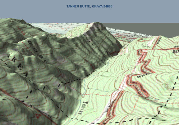
This 3D map was generated looking out from the high point of the
trail.
The road is between the two red lines on the right (east) side
of canyon.
That incredible point at top center of picture is Munra Point.

Ellen got off with the light load!

This is the trailhead for a trail Scott and the children took
once before.
They could park the car here then. We met up with a party of three
hikers
and a lone cyclist on his way down, who said the gate at the bottom
had
been locked for about two years. They were the only folks we saw
all day.

Scott pumps water from the creek to replenish our supply --
we had finished most of what we were carrying already!

One of the hikers offered to take our picture together.

At the top of the climb you could see Munra Point, across Tanner
Creek...

...and in the other direction, Mt. Telapus (on the right).
As you can see, we are right under the power lines.

Here's the 3D map view from the same point that we generated afterward,
to find out what that prominence in the center is (as it turns
out, it doesn't
have a name, but at least we can pick it out on the map).

Scott knows exactly where we are!

Out of the sun and back into the forest, we crossed this lovely
quintessential Oregon stream.
From here on the road was pretty much downhill (whee!) to the
trailhead.

Scott thought we might be able to ride our bikes the mile and
a quarter on the trail
to the campsite. But the going was just a little too rough. When
we reached the
first creek we decided to eat lunch and then park our bikes and
hike on.

The trail is quite old, and it doesn't seem to be maintained a
lot any more.
At the first fork in the trail we found this helpful trail marker
sign!

This was typical -- older downed logs had been cut, but more
recent falls had to be climbed over.

It turned out there were lots of streams to cross. Only a couple
had bridges.

There was lots of Devil's Club and Salmonberry to get through.
Can you see Scott in the middle? This IS the trail.
_huckleberry.jpg)
But there were also lots and lots of huckleberries, both red and
blue, to feast on!

Did I mention there were lots of streams to cross?

In an Alder branch across the trail there was this bird's nest.

At last we reached our destination: Tanner Creek. This was about
6:30 p.m.
So, in typical Parker fashion, we got back to the car just after
the sun set!

This map shows the route of the bike ride, along with the elevation
profile.
The blue line was the plan, and the magenta line with black dots
is what we really did.

This map shows the hike. The long blue section we didn't go on
is the Moffat Creek Trail.
Can you guess from the elevation profile where we stopped?

Adventures Index
info@ellenvanderslice.com